If you're sore from shoveling snow, at least there's an end in sight: The National Weather Service says precipitation is expected to taper off between 11 p.m. tonight and 4 a.m. Monday morning.
But what's already fallen so far was blamed for an apparent avalanche in part of Luzerne County, and more snow could be coming.
Areas of Northeast Pennsylvania could still see more snow during the day on Monday, the agency's Binghamton, N.Y. office says, with a winter storm warning still effect until 7 p.m.
By the time the storm is over an estimated 12 to 18 inches of snow will have fallen across the region.
Next five days: Bitterly cold
What's not over is the bitter cold which accompanied the storm.
Scranton and Wilkes-Barre will see highs of about 25 today, highs in the teens for Tuesday through Thursday, and lows between 3 degrees and -1 degree, not pushing back up into the 20s until at least Saturday.
Conditions are expected to be sunny or partly cloudy for the rest of the week — but cold.
Coxton Road avalanche

Duryea Fire Police in Luzerne County reported on their Facebook page that "significant snow slides" had fallen onto Coxton Road Sunday, making the road impassible beyond the 900 block.
"Please find an alternate route and continue to avoid traveling unless absolutely necessary," the post said, adding that PennDOT had been made aware of the issue.
A vast storm

The weather system which brought heavy snow and extreme cold to the region was not unique to our region.
It was part of a much larger storm thar dumped sleet, freezing rain and snow across much of the U.S. on Sunday, as The Associated Press reported, stretching from New Mexico to New England.
Nearly a million customers across the South were without power on Sunday evening, as the effects of the weekend's massive weather system began to take hold, NPR reported.
How much snow has fallen?
Here are selected snowfall totals from around the region as of Sunday, per NWS:
Bradford County
● Troy — 10.5 inches as of 5 p.m.
Lackawanna County
● Carbondale — 9.5 inches as of 4 p.m.
● Old Forge — 10 inches as of 4:40 p.m.
● Scranton — 9 inches as of 4 p.m.
Luzerne County
● Drums — 16 inches as of 4:30 p.m.
● Kingston — 12 inches as of 6:30 p.m.
● Nanticoke — 12 inches as of 5:10 p.m.
● Pittston — 11.5 inches as of 4:34 p.m.
Pike County
● Milford — 13.7 inches as of 6:30 p.m.
Susquehanna County
● Forest City — 10 inches as of 5:07 p.m.
● Great Bend — 10 inches as of 4:30 p.m.
Wayne County
● Hawley — 12.8 inches as of 5:45 p.m.
● Waymart — 12 inches as of 4 p.m.
Wyoming County
● Factoryville — 16.2 inches as of 4 p.m.
● Nicholson — 9 inches as of 4:45 p.m.

PEMA: 'We did it'
Pennsylvania State Police, PennDOT and Pennsylvania Emergency Management Agency officials on Friday strongly urged residents to stay home on Sunday and on Monday as needed while crews work to clean roads in the storm's wake.
PEMA on Sunday evening suggested that the message was largely heeded.
"We did it, Pennsylvania! We made it through most of this snow while keeping each other safe," the agency posted on X.
PEMA advised that residents should continue to stay off the roads if they can.
Expect a quiet Monday
Already on Sunday there were widespread reports of businesses and organizations announcing closures and delays for Monday.
This list is not comprehensive, and you should check before heading out — bearing in mind that officials are still encouraging residents to stay off the roads Monday unless absolutely necessary.
PennDOT and roads
Information about road conditions and restrictions can be found on the 511pa.com page.
Public transportation
● County of Lackawanna Transit System said all COLTS operations will be closed on Monday.
● Luzerne County Transportation Authority will suspend all service on Monday and close its offices. Check LCTA's social media and lctabus.com for important service alerts regarding Tuesday service.
● Monroe County Transit Authority will not provide service on Monday.
● Martz Bus canceled all service on Sunday. It will begin resuming New York-Pennsylvania service at noon on Monday, but service from Northeast Pennsylvania to Philadelphia won't resume until Tuesday. Details here.
● River Valley Transit Authority in Williamsport will begin service at 9 a.m. on Monday.
● Schuylkill Transportation System has suspended all service for Monday.
Government services
● Carbon County — County government offices will be closed on Monday.
● Lackawanna County — All county and court offices will be closed on Monday, and a disaster emergency has been declared. All essential county personnel must report to work.
● Luzerne County — All county buildings will be closed on Monday.
● Lycoming County — County business offices will be working on an alternate schedule. Administrative offices will be closed until noon on Monday. Watch for updates on the county website if conditions deteriorate.
● Monroe County — County and court offices will be closed on Monday.
● Pike County — Government, administrative and court offices will be closed on Monday.
● Wayne County — The courthouse, administrative offices and recycling center will be closed Monday. The Wayne County Senior Centers, Adult Daily Living Center, and take-out and home-delivered meals, are canceled for Monday.
● Wyoming County — The courthouse will be closed Monday for all nonessential employees.
***
ORIGINAL STORY: Friday, Jan. 23, 2026
The National Weather Service is predicting at least a foot of snow for most of the region during this weekend's winter storm, and state officials have a simple message for residents across Pennsylvania.
"If you don't need to be on the roads, please stay home," Lt. Colonel George Bivens, Pennsylvania State Police Acting Commissioner, said Friday.
State Transportation Secretary Mike Carroll reframed that advice for sports fans.
"My preference would be a Sunday stay home day — watch the NFL games, despite the fact that the Eagles and Steelers are not playing," Carroll said.
Gov. Josh Shapiro on Friday signed a Proclamation of Disaster Emergency to make resources available to prepare for and support response efforts for the upcoming storm.
When will the snow start? How long will it last?
The National Weather Service says a winter storm warning will be in effect beginning at 1 a.m. Sunday, which is when the snow is generally expected to move into the region, and the warning is in effect through 7 p.m. Monday.
The bulk of the snow is expected to fall in the 24 hours between 7 a.m. Sunday and 7 a.m. Monday. in Northeast Pennsylvania, potentially starting as early as 10 p.m. Saturday in areas of Central Pennsylvania.
The photo gallery below shows NWS' expected timing for snowfall in Northeast Pennsylvania.


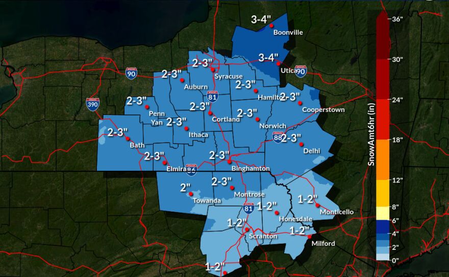
How much snow will we get?
That will vary by location, but for much of WVIA's coverage, the answer is at least 12 inches, with snowfall starting in the early hours of Sunday and continuing until Monday evening. Snowfall rates of 1 to 2 inches per hour are expected by Sunday afternoon.
- The NWS Office in Binghamton, N.Y., which covers Northeast Pennsylvania (Bradford, Susquehanna, Wayne, Wyoming, Lackawanna, Luzerne and Pike counties) is generally stating 12 to 18 inches can be expected in that area.
- Some neighboring areas in New York State, particularly from Binghamton east to the Catskills and Hudson Valley, could see 18 inches or more, NWS says.
- The NWS Office in State College, which covers Central Pennsylvania, predicts between 10 and 18 inches in that region.
- The NWS Office on Mount Holly, N.J., which covers areas of Eastern Pennsylvania, is predicting 12 to 18 inches in Carbon, Monroe, Lehigh and Northampton counties, and possibly a light glaze of ice.
“Just expect, in this event, one or two inches per hour rates, with chances for up to three during peak storm timeframes,” said Kaitlyn Lardeo, a meteorologist with NWS Binghamton.
The storm is most likely to be an all snow event, NWS officials said, and a 15 to 1 snow to liquid ratio will make that snow dry and fluffy.

Brace for extreme cold
Heavy snow isn't the only challenge facing Pennsylvanians. NWS officials say extreme cold temperatures and wind chills will descend on the region between Friday evening and Monday morning. As shown in the graphic above, that could include lows of 1 degree in Hazleton and Honesdale, and 4 degrees in Scranton and Wilkes-Barre. And that bitter cold will stick around through the week.

Officials want drivers off the road
As stated above, transportation officials and police are urging people to stay home if at all possible on Sunday into Monday.
Tier 4 commercial vehicle restrictions will be implemented at 12:01 a.m. Sunday, meaning no commercial vehicles are permitted on the entire Interstate network, on the Pennsylvania Turnpike and all of its extensions, and on other major roadways in Pennsylvania.
Information about the restrictions will be communicated via digital highway message boards, the 511PA traveler information website, and smartphone apps. Drivers can also sign up for personalized alerts on the website.
Restrictions will be lifted as quickly as possible when conditions permit, officials said.
"We are already pre-treating roads in anticipation of the storm, and we will be working around the clock to keep our roads safe and passable," Carroll said. "However, we're expecting snow to be falling at rates of one to two inches per hour during the height of the storm, which poses the real challenge for our plowing operations."
"It's worth reminding folks that PennDOT has 44,000 miles of roadway. So it's an impossible assignment for them to be bare and clear during the entire storm," Carroll added.
State plows focus on the Interstate and high-volume roadways first, he said, and then move down from there.
Drivers can see where the plow trucks have been and how recently the road has been cleared at the 511 PA website, he said.